
Showing posts with label kyushu. Show all posts
Showing posts with label kyushu. Show all posts
August 4, 2011
Japanese Ginkgo Leaves (fall's last hope in the face of winter)
I wanted to make a video that said goodbye to fall and embraced the long cold winter to come. The ginkgo leaves , which held their shape and color until the beginning of the winter, were the best and last standing representative of fall I could find.
I think the images show a little bit of fall and the soundtrack "Mir" by Doc foreshadows the winter to come. The video was filmed on a Canon T1i with a Tamron 28-75mm 2.8f lens.


August 1, 2011
Japan International Balloon Fiesta (saga) 佐賀インターナショナルバルーンフェスタ
A trip to Saga-ken, Japan for the 10th annual International Balloon Festival held in November 2010. The five-day festival received over 500,000 visitors and had contestants from Switzerland, America, Sweden, China, among other countries. On the fourth day of the festival, mother nature provided a beautiful sunset as balloons came into the landing area. Being there felt like being in some alternate reality fantasy novel where balloons were the main form of air transport and the Hindenburg had never gone up in flames. It was an amazing sight! The night fantasia at night where the balloons light up to music was wonderful too. Enjoy the pictures and video.
For more information on the festival visit the following link: http://www.sibf.jp/
1st track Sean Wright - Naked Shoulders
2nd track Adragante - Kerridwen
April 7, 2011
Beautiful Sunset + Hot Air Balloon Festival = Amazing!
A trip to Saga prefecture in Japan for the 10th annual International Balloon Festival held in November 2010. The five-day festival received over 500,000 visitors and had contestants from Switzerland, America, Sweden, and China among other countries. On the fourth day of the festival, mother nature provided a beautiful sunset as balloons came into the landing area. Pilots attempted to drop a marker onto one of two targets. The closer the marker the higher the score.
This was my first hot air balloon festival and it felt like being in some alternate reality fantasy novel, where balloons were the main form of air transport and the Hindenburg had never gone up in flames. It was an amazing sight!
If you have the chance to go to a local festival, don't miss out. It will surely amaze you.
For more information on the festival visit the following link: http://www.sibf.jp/
------
This video is available under a Creative Commons Attribution - Share Alike license
January 18, 2011
Nature Japan - Exploring Caves
The caves of Inazumi in Oita Prefecture were naturally formed and contain some of the purest water in Japan. People come from all over not only to see them, but to collect water and take it back home. One of the local restaurants even exclusively serves its water. I recommend a visit, they are amazing and 18 degrees Celsius all-year-round. Great in the summer! The network of caves is broken into two branches with each measuring around 200 meters in length. Below is a description in Japanese as posted on the official website:
稲積水中鍾乳洞は3億年前の古生代に形成され、 30万年前の阿蘇火山大噴火により水没し現在の形を形成しました。
洞内には水中鍾乳石や珊瑚石、ベルホール、ヘリクタイトなどが 数多く見られる世界的にも珍しい水中鍾乳洞です。
無数の鍾乳石、水深 40mをこえる深渕、未知の洞奥から湧き出る清流、 その清らかな水が、千変万化の美をおりなし 水中鍾乳洞のコントラストは訪れる人たちを幻想の世界へ導いてくれます。
また、洞内の温度は一年中16度で、夏は涼しく、冬は暖かいため一年を通してすばらしい水中鍾乳洞をご覧いただけます。
マイナスイオンを感じる洞内で心も体も癒されます。
July 12, 2009
The Source of the Ono River - 白水の滝
A pit stop at 白水の滝 in 荻町 on my way to Mt. Aso (阿蘇山), the volcano that helped form Kyushu and holds the record for largest volcanic caldera in the Japan. I muse over rural life and give some advice to new JETs placed in the Japanese countryside.
July 9, 2009
July 2, 2009
Hiking Japan's Largest Active Volcano - Mt. Aso

On July 27th I decided to go hiking, my new hobby since I’ve come to rural Japan. Having already climbed Mt. Yufu twice and hiked on and around Mt. Kuju a few times it was time to stretch my legs a little. I fixed my eyes on Aso-san (阿蘇山) in the neighboring prefecture of Kumamoto--an active volcano whose volcanic eruptions formed the island of Kyushu (Japan’s third largest island). It also is one of the world’s major volcanic caldera and is Japan's largest active volcano.
(**Edit: Most of Kyushu was formed by the subduction of the Philippine plate under the Eurasian plate, not by Aso's eruptions, which are relatively recent. Thanks to CJW for the correction)
The volcano offers a couple hiking routes with views of the still fuming crater and the Aso caldera. The route I choose took me from the Sensuikyou car park (仙酔峡駐車場) at the base of the Sensuikyou Rope Way up to the edge of the crater then off to the top of Naka-dake, (中岳) which overlooks the crater from a height of 1,506 meters. The second summit of the day, Taka-dake (高岳 1,592 meters), followed and I ended with a very steep descent to the car park via Sensuikyou Ridge (仙酔尾根).
I was able to complete the route in less than 4 hours without pushing too hard and often stopping to take photos and video. The first leg of the hike from the car park to the rim of the volcano is a steep and steady assent and required about 30 minutes of hiking that got me sweating in the end of June heat (30 c). However, you are quickly rewarded with a wide-open view of Aso-san’s crater and smoke plumes of noxious gases that depending on the wind can close the surrounding hiking trails. Behind you is a sweeping view of the Aso caldera and the town of Aso. The surrounding scenery and landscapes of jagged and reddish volcanic rock offer something new that I had not seen elsewhere on Kyushu.
I was able to complete the route in less than 4 hours without pushing too hard and often stopping to take photos and video. The first leg of the hike from the car park to the rim of the volcano is a steep and steady assent and required about 30 minutes of hiking that got me sweating in the end of June heat (30 c). However, you are quickly rewarded with a wide-open view of Aso-san’s crater and smoke plumes of noxious gases that depending on the wind can close the surrounding hiking trails. Behind you is a sweeping view of the Aso caldera and the town of Aso. The surrounding scenery and landscapes of jagged and reddish volcanic rock offer something new that I had not seen elsewhere on Kyushu.

With my back to the volcano, I began trekking toward the first summit of the day. As I gained elevation the valley on the opposite-side of Aso-san revealed itself. From the picture below, you can see hills that appear as if they were rivulets scrapped into the base of the rising mountain.

I soon reached the summit without trouble and decided to continue on to Taka-dake which was steeped in clouds. The path was more strenuous with various obstacles, but nothing a fellow hiker should worry about. Being the highest point in the surrounding area, it would have felt great to survey the area and look down on the car park that I had left behind just 2 hours ago, but sadly I was surrounded by clouds and the wind was picking up so I decided to start my descent. Oh and was I in for a surprise.

Up until that point, the trails had been clearly marked and pretty well groomed. The final leg of the journey proved otherwise. As I descended the Sensuikyou Ridge, it became apparent that not many hikers ventured this far including the personnel responsible for remarking the trails. What had once been a trail marked with bright yellow spray painted arrows turned into weather beaten half-rotted poles from yester-year. These soon disappeared and intermittent faded yellow dots replaced them. The conditions of the “trail” took a turn for the worse too. The side of the mountain was covered with small and medium-sized volcanic rock, which is light when compared to your average trail rock on a density/volume scale. This resulted in the small rocks sliding out right from under you and when you tried to regain your balance by bracing your foot on a larger rock that too started to roll. Not good conditions especially when you are losing all the elevation you gained over 4.5 km in 1.5 km (and over half in the first .7 km). I thought of turning back, but knowing what I had to go up made me continue on my course. Needless to say, I made it back to the car park without major incident, but I cannot recommend the final leg of my hike to anyone. It was slow going and there were a couple “Oh Shit!” moments.

The hiking on and around Aso-san was the most interesting I have experienced yet in Kyushu. While the trail offerings are by no means as extensive as those on Kuju and its surrounding plateau, what it has is quality and its landscapes offer something different from your run-of-the-mill brush and cedar trees that cover so much of Kyushu’s protected nature areas.
For a good blog post by a Japanese hiker who hiked pretty much the same route check this out.
For a good blog post by a Japanese hiker who hiked pretty much the same route check this out.
November 26, 2008
Hiking in the Kuju Mountain Range
Well, it certainly is Fall here in Japan and that means I'm freezing and about to die? Yes, but that is not what I'm getting at. It means 紅葉 Fall foliage and pristine hiking. About 3 maybe 4 weeks back, when the leaves where just starting to change, I took a little road trip to the Kuju mountain range 久住山々, which is in Aso-Kuju National Park, to test my feet on its slopes.
I was not disappointed. In fact, I was floored to find out that there is hiking of this caliber in my relative area--Hiking trails of all levels are abundant, even a "marathon" park with different exercise courses (aka flat walks), quite a few summitable peaks and genuine splendid natural beauty not to mention a copious amount of onsen 温泉 to sooth those aching muscles and feet after a hard days hike. There is even a flower park くじゅう花公園. I am already planning to return and spend the night this time in one of the many ryokan 旅館 that spot the Kuju Plateau. This time I hope to climb Mt. Nakadake, which is the highest mountain in Kyusyu standing at 5870 feet/1,791m. I think this might become a regular hiking place for me. After searching around for some photos, the mountain range looks great in winter and spring too.
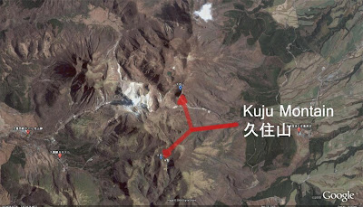 Here is an overhead view from Google Earth
For more info from another blogger, check out this post.
I was not disappointed. In fact, I was floored to find out that there is hiking of this caliber in my relative area--Hiking trails of all levels are abundant, even a "marathon" park with different exercise courses (aka flat walks), quite a few summitable peaks and genuine splendid natural beauty not to mention a copious amount of onsen 温泉 to sooth those aching muscles and feet after a hard days hike. There is even a flower park くじゅう花公園. I am already planning to return and spend the night this time in one of the many ryokan 旅館 that spot the Kuju Plateau. This time I hope to climb Mt. Nakadake, which is the highest mountain in Kyusyu standing at 5870 feet/1,791m. I think this might become a regular hiking place for me. After searching around for some photos, the mountain range looks great in winter and spring too.
 Here is an overhead view from Google Earth
Subscribe to:
Posts (Atom)