
July 30, 2009
Japanese Subculture + Peter Bjorn & John
A great video showcasing a subculture that exists in Japan. If you walk around Tokyo on the weekend you will no doubt see these greasers dancing about. The song is "Nothing is Wrong" by Peter Bjorn & John.
July 17, 2009
July 16, 2009
A Little Slice of Heaven in Miyazaki

After a year of living on the island of Kyushu, I finally made it to Miyazaki-ken known for its beaches, surfing, and chicken nanban. I now find myself asking, "what took so damn long?" Everyone has their little bit of heaven on earth, and I think I just found mine.

The plan had me and some friends camping on Shimoaso beach (下阿蘇ビーチ) just north of Nobeoka (延岡) which is located in the northern part of the prefecture. We armed ourselves with newly bought tents, an ¥800 BBQ grill, and MEAT. But you live in Japan, isn't meat expensive? Well if you have a friend who lives near Costco in Fukuoka, two giant steaks, pork chops, shrimp, chicken wings, and bratwursts are no problem. Yes, we did consume all that in one meal and we even threw in some eggplant, shitake mushrooms, and green peppers to boot.

Our camping spot was surrounded with palm trees and a nice sand beach stretched out to our left and right. The facilities were great; shower, bathroom, power outlets, and tables all within reach. After the rained stopped around 4pm, it was smooth sailing and the camping out experience really enhanced our trip. A stay in a local hotel or even a cabin wouldn't have improved the trip. Conversely, I would say it would have detracted from it.

On the second day, we went for a morning swim out to a chain of rocks off the shore and relaxed listening to the sound of waves lap against the shore. Afterward, we forwent the local showers and found our way to a nice お風呂 and soaked in some hot water. What better way to follow that up then with some sushi.

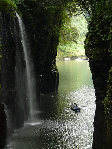
We packed up and left our little haven to check out Takachiho Gorge (高千穂峡), which was formed by the lava flows of Mt. Aso, in neighboring Kumamoto-ken. It was stunning. See the pictures below for yourself.

Not bad for a weekend trip and to think it is all under a 90 minute drive from my house. I will definitely head back. In fact, I will be heading to southern Miyazaki in about a months time. I wish you could see the smile on my face.
July 12, 2009
The Source of the Ono River - 白水の滝
A pit stop at 白水の滝 in 荻町 on my way to Mt. Aso (阿蘇山), the volcano that helped form Kyushu and holds the record for largest volcanic caldera in the Japan. I muse over rural life and give some advice to new JETs placed in the Japanese countryside.
July 9, 2009
July 2, 2009
Hiking Japan's Largest Active Volcano - Mt. Aso
On July 27th I decided to go hiking, my new hobby since I’ve come to rural Japan. Having already climbed Mt. Yufu twice and hiked on and around Mt. Kuju a few times it was time to stretch my legs a little. I fixed my eyes on Aso-san (阿蘇山) in the neighboring prefecture of Kumamoto--an active volcano whose volcanic eruptions formed the island of Kyushu (Japan’s third largest island). It also is one of the world’s major volcanic caldera and is Japan's largest active volcano.
(**Edit: Most of Kyushu was formed by the subduction of the Philippine plate under the Eurasian plate, not by Aso's eruptions, which are relatively recent. Thanks to CJW for the correction)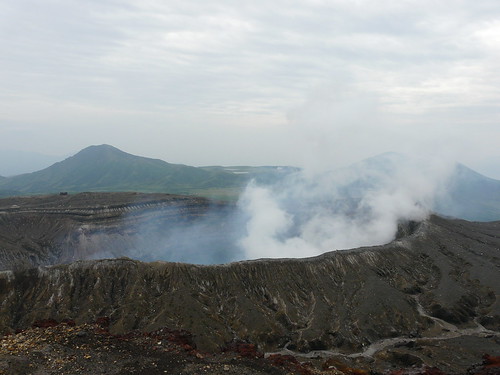
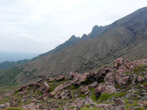
The volcano offers a couple hiking routes with views of the still fuming crater and the Aso caldera. The route I choose took me from the Sensuikyou car park (仙酔峡駐車場) at the base of the Sensuikyou Rope Way up to the edge of the crater then off to the top of Naka-dake, (中岳) which overlooks the crater from a height of 1,506 meters. The second summit of the day, Taka-dake (高岳 1,592 meters), followed and I ended with a very steep descent to the car park via Sensuikyou Ridge (仙酔尾根).
I was able to complete the route in less than 4 hours without pushing too hard and often stopping to take photos and video. The first leg of the hike from the car park to the rim of the volcano is a steep and steady assent and required about 30 minutes of hiking that got me sweating in the end of June heat (30 c). However, you are quickly rewarded with a wide-open view of Aso-san’s crater and smoke plumes of noxious gases that depending on the wind can close the surrounding hiking trails. Behind you is a sweeping view of the Aso caldera and the town of Aso. The surrounding scenery and landscapes of jagged and reddish volcanic rock offer something new that I had not seen elsewhere on Kyushu.
I was able to complete the route in less than 4 hours without pushing too hard and often stopping to take photos and video. The first leg of the hike from the car park to the rim of the volcano is a steep and steady assent and required about 30 minutes of hiking that got me sweating in the end of June heat (30 c). However, you are quickly rewarded with a wide-open view of Aso-san’s crater and smoke plumes of noxious gases that depending on the wind can close the surrounding hiking trails. Behind you is a sweeping view of the Aso caldera and the town of Aso. The surrounding scenery and landscapes of jagged and reddish volcanic rock offer something new that I had not seen elsewhere on Kyushu.
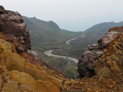
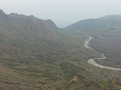
With my back to the volcano, I began trekking toward the first summit of the day. As I gained elevation the valley on the opposite-side of Aso-san revealed itself. From the picture below, you can see hills that appear as if they were rivulets scrapped into the base of the rising mountain.
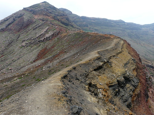
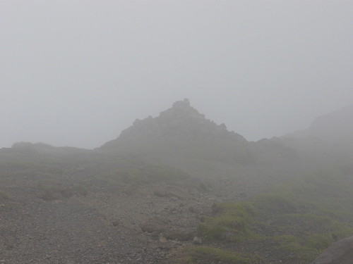
I soon reached the summit without trouble and decided to continue on to Taka-dake which was steeped in clouds. The path was more strenuous with various obstacles, but nothing a fellow hiker should worry about. Being the highest point in the surrounding area, it would have felt great to survey the area and look down on the car park that I had left behind just 2 hours ago, but sadly I was surrounded by clouds and the wind was picking up so I decided to start my descent. Oh and was I in for a surprise.
Up until that point, the trails had been clearly marked and pretty well groomed. The final leg of the journey proved otherwise. As I descended the Sensuikyou Ridge, it became apparent that not many hikers ventured this far including the personnel responsible for remarking the trails. What had once been a trail marked with bright yellow spray painted arrows turned into weather beaten half-rotted poles from yester-year. These soon disappeared and intermittent faded yellow dots replaced them. The conditions of the “trail” took a turn for the worse too. The side of the mountain was covered with small and medium-sized volcanic rock, which is light when compared to your average trail rock on a density/volume scale. This resulted in the small rocks sliding out right from under you and when you tried to regain your balance by bracing your foot on a larger rock that too started to roll. Not good conditions especially when you are losing all the elevation you gained over 4.5 km in 1.5 km (and over half in the first .7 km). I thought of turning back, but knowing what I had to go up made me continue on my course. Needless to say, I made it back to the car park without major incident, but I cannot recommend the final leg of my hike to anyone. It was slow going and there were a couple “Oh Shit!” moments.
The hiking on and around Aso-san was the most interesting I have experienced yet in Kyushu. While the trail offerings are by no means as extensive as those on Kuju and its surrounding plateau, what it has is quality and its landscapes offer something different from your run-of-the-mill brush and cedar trees that cover so much of Kyushu’s protected nature areas.
For a good blog post by a Japanese hiker who hiked pretty much the same route check this out.
For a good blog post by a Japanese hiker who hiked pretty much the same route check this out.
Subscribe to:
Posts (Atom)